
San Francisco Loop (US - 7 days)
Route Overview
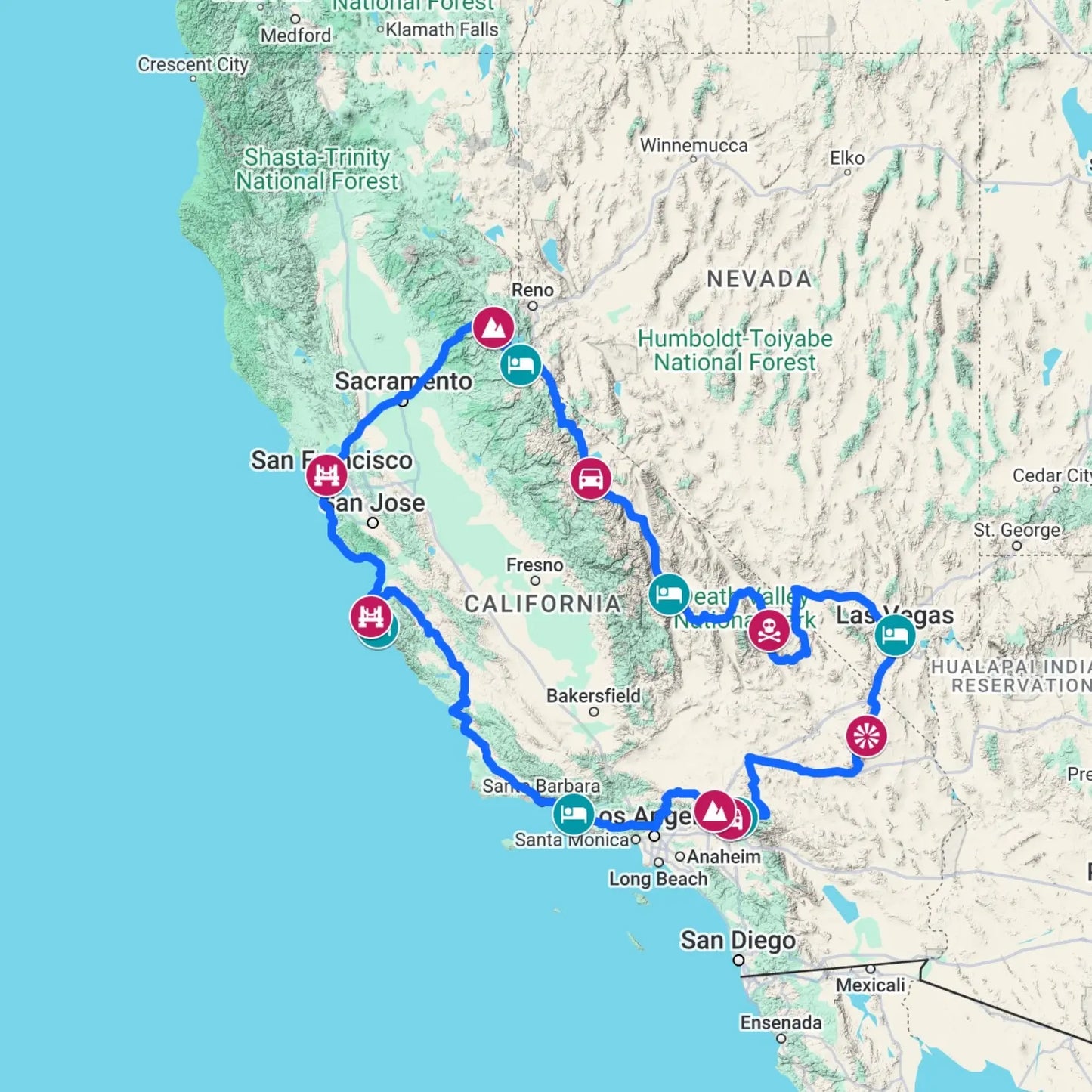
The Great Western Loop: A California & Nevada Multi-Biome Expedition
Experience the definitive American West road trip, a circular journey starting and ending in San Francisco. This route spans four distinct ecosystems: the rugged Pacific Coast, the high-alpine Sierra Nevada, the arid Mojave Desert, and the lush National Forests of Northern California.
Experience one of the best road trips in the USA on this unforgettable journey through California and Nevada. Starting in San Francisco, this epic driving route combines iconic cities, dramatic landscapes and world-famous roads into one seamless adventure.
Travel from the vibrant streets of San Francisco to the towering peaks of the Sierra Nevada, before exploring the otherworldly landscapes of Death Valley - one of the most unique desert environments on Earth. Continue to the neon energy of Las Vegas, where entertainment and nightlife meet the desert skyline.
The journey then winds through scenic desert preserves, alpine lakes, and dramatic mountain passes before joining the legendary Pacific Coast Highway for a breathtaking coastal drive back to San Francisco.
Iconic Landmarks & Geography
- Death Valley National Park: Descend into Badwater Basin, the lowest point in North America (86m below sea level), and witness the surreal "moving rocks" and salt flats of the Mojave.
- The Las Vegas Strip: Transition from desert solitude to the high-energy neon corridor of Nevada’s most famous city.
- The Pacific Coast Highway (PCH/Highway 1): Conclude your journey with a legendary drive along the Big Sur coastline, crossing the iconic Bixby Creek Bridge on your way back to the Bay Area.
Itinerary
- Day 1: Donner Pass to Lake Tahoe
- Day 2: Highway 395 & the June Lake Loop
- Day 3: Death Valley (Badwater Basin) to the Las Vegas Strip
- Day 4: Mojave National Preserve to the Rim of the World Scenic Byway
- Day 5: Rim of the World Scenic Byway & Cajon Pass
- Day 6: The Pacific Coast Highway (highway 1) & Big Creek Bridge
- Day 7: Bixby Bridge & Golden Gate Bridge
Landscape Diversity: Four Environments in One Trip
| Environment | Key Highlight |
| Alpine | Lake Tahoe & The Sierra Peaks |
| Desert | Mojave Preserve & Death Valley |
| Coastal | Monterey Bay & The Pacific Cliffs |
| Urban | San Francisco's Golden Gate & Las Vegas |
Why choose this California & Nevada road trip?
- One of the most diverse road trips in the United States
- Combines mountains, desert, coastline and iconic cities
- A bucket-list journey linking some of America’s most iconic landscapes and destinations
Traveller Advisory: Be mindful of seasonal pass closures in the Sierra Nevada (typically Nov–May) and extreme summer temperatures in Death Valley, where conditions can be hazardous for certain vehicles.
Trip Information
- No of Days: 7
- Estimated Daily Drive: 4 hrs 37 mins
-
Estimated Max Elevation: 2,484m (8,149ft)
Basic Itinerary
Couldn't load pickup availability
Frequently Asked Questions
What are the "Four Biomes" I will experience?
This itinerary is unique because it transitions through four distinct environments - Coastal: The rugged cliffs and redwood air of the Pacific Coast Highway. Alpine: The high-altitude peaks and crystal waters of the Sierra Nevada and Lake Tahoe. Desert: The arid, otherworldly salt flats of Death Valley and the Mojave. Urban: The iconic skylines of San Francisco and the neon corridor of Las Vegas.
Which states does this route cover?
This journey spans California and Nevada, showcasing some of the most diverse landscapes in the American West.
How much time will I spend driving each day?
The trip is paced over 7 days, with an average daily drive time of 4 hours and 37 minutes. This allows you to tackle the long desert stretches while still having time to hike in the Sierras or explore the Las Vegas Strip.
What is the highest and lowest point of the trip?
The contrast is staggering! You will reach an estimated maximum elevation of 2,484m (8,149ft) in the Sierra Nevada mountains. Conversely, you will descend into Badwater Basin in Death Valley, which is the lowest point in North America at 86m (282ft) below sea level.
How hot does it get in Death Valley?
Temperatures in Death Valley National Park can exceed 45°C (113°F) in summer. Travellers should plan accordingly, carry water, and avoid driving during peak heat.
Can I drive this route in the winter?
You must be careful with timing. The mountain passes in the Sierra Nevada (such as Donner Road Pass) typically close from November to May due to heavy snow. If you travel in winter, you may need to take a more southerly detour.
Will I drive the Pacific Coast Highway (PCH)?
Yes. The final leg of the journey includes a legendary stretch of Highway 1, featuring the world-famous Bixby Creek Bridge and the dramatic coastal vistas of Big Sur as you head north toward San Francisco.
Are there any specific vehicle requirements?
A standard vehicle is fine for the main highways, but ensure you have a full tank of gas before entering Death Valley or the Mojave Preserve, as service stations can be 50–100 miles apart.
What makes this route unique compared to other US road trips?
Few routes combine four completely different environments—coastline, mountains, desert, and urban experiences—into one seamless loop, making this a true bucket-list journey.
Are there any other coastal driving routes similar to the Pacific Coast Highway?
Absolutely. While the PCH is iconic for its California sunshine and Big Sur cliffs, if you enjoy this coastal section, check out our Wild Atlantic Way itinerary for a similar rugged experience in Ireland. It offers the same dramatic Atlantic vistas but with a uniquely European, windswept character.